|
MOUNT PAPANDAYAN TOUR
"In January 1706, two
Dutch soldiers named Creatiaun and Van Houten had the duty of the local
prefecture to visit, investigate and search for pure sulfur in Mount
Papandayan and Mount Patuha. At that time, Mount Papandayan still there in
full height "(Kusumadinata, 1970)"
Long time before the Dutch people find this mountain, local communities have
often crossed Mount Papandayan to bring tobacco, salt, vegetables, and the
results of the other earth. This point is the nearest road that connects
the highlands to the valley Canning Bandung Garut.
Papandayan name, derived from the language sunda "Panday" which means
blacksmith. In the past, when people across the mountains, often sounds
like workplace conditions smiths, the sound was coming from a very
active crater. Thus this mountain was renamed by the community
Papandayan around this mountain.
Mount Papandayan located around 25 km southwest Garut regency, with the
geographical position of 7o19 'South latitude and 107 o 44' East
Longitude with an altitude of about 2665 M or about 1950 M above the
plains Garut. South of this mountain there is Mount Guntur and adjacent to east
there is Mount Cikuray.
Mount Papandayan is the most southern cone of the volcano row in southern
Priangan have classified (since the Dutch colonial era) as the active
volcanoes are quite dangerous in West Java. Eruptions that occurred
since ancient times to make this mountain forms a horseshoe like pieces.
The crater is located in Tegal alun-alun which has long since dead
and turned into an open field. This old crater walls form a complex of
mountains with peaks of Mount Malang (2675 M), Mount Masigit (2619
M), Mount Saroni (2611 M) and Mount Papandayan (2665 M) that surround the
town square of Tegal. This field appears in the spring that became
Ciparugpug River.
Horseshoe around this area, we can also see the small mountains that
surround Mount Papandayan, among others, Mount Puntang (2555 M),
Mount
Walirang (2238 M), Mount Tegal Paku ( 2225 M) and Mount Jaya (2422 M). While among Mount Puntang and Mount There Walirang Cede
Cibeureum river which flows into the River Cimanuk.
Eruption History
In recorded history, major eruptions have occurred in Mount Papandayan on
11 - August 12, 1772. major eruption caused the destruction of some body
of this mountain, forming a horseshoe crater open towards the northeast.
"With a booming voice and a great sound, after the middle of the
night suddenly seemed to rise up the rays of light, which illuminate the
darkness, breaks down the top of the mountain, throwing and spread
loaf on to surounding". Such records F.W. Junghuhn, a German
mountain explorer of the outbreak of Mount Papandayan on August 11, 1772.
This biggest eruption of mount Papandayan recorded in history. Besides
destroying part of his body, this eruption also destroyed 40 villages
Garut highland, eat more or less casualties and killed 2957 people
of more than 1500 head of cattle, buffaloes, goats, animals and other
pets.
In 1819, the founder of Bogor botanical garden, a germany Reindwardt CGC
became the first foreigner to climb this mountain. In this
period, Mount Papandayan becoming a haven for volcano experts and the
plants until now.
R.D.M. opinion Verbeek and R. Fennema, eruption Mount Papandayan in the
year 1772 took place as was the case in Mount Semeru in East Java in 1885,
but more powerful. At the time of the eruption of vomit fire was visible
for 5 minutes from the crater Papandayan (crater Mas), followed by rock
avalanches that destroyed the lower regions. Events falling rock
avalanches tersebutlah which is the subject of the event eruption Mount
Papandayan in the year 1772.
After that, the mountain was having a quiet again until March 11, 1923
at Papandayan crater (crater Mas) began swirling again until March 9,
1925. Over 2 years, a small explosion did not harm often occurs in this
mountain.
Eruption that occurred on March 11, 1923 was recorded from the crater
contained in Tegal Alun-alun, the eruption of mud and rocks for heads
who came out to about 150 AD
According to Head and population CISURUPAN, eruption on March 11, 1923
occurred at night preceded by a mild earthquake. This explosion of
events, the eruption of new field has been discovered and named New
crater. In a field as wide as 100 AD eruption, the eruption of 7 holes
were discovered and a small lake has formed.
Along with the formation of new craters above, in June 1923, at the foot
of Mount Nangklak (a steep wall of the south crater Mas) has also formed a
new crater crater named Nangklak with the eruption of 3 holes in it.
Throughout the years 1924 to 1925, small eruptions occur alternately in
each of the different crater of the mountain until the program finally
entered a period long enough rest to a large eruption occurred back on
November 11, 2002.
On Monday, 11 November 2002 at 15:30, Mount Papandayan restart operations
after nearly 60 years in the rest.
Eruption in 2002 was preceded by a small eruption freatik on 1 to 3
October 2002, which occurred in the crater Mas causing increased
activity of this mountain. Mas crater temperatures have increased and
could burn the sulfur deposits contained therein.
On November 10, 2002, Post Mountain Fire Observation Papandayan noted a
significant increase in the number of type B Volcanic Earthquake of 60
times. This earthquake marks the chasm and land systems in the region
Mas crater becomes saturated with water vapor and pressure, and activate
the steam system in the crater to the eruption Mas freatik next.
On November 11, 2002, the first eruption occurred at freatik New crater
at 16:03 pm, which is a concentrated blast of dust into the air which
reaches a height of 5 km from the summit. Explosion at New crater caused
a massive landslide Nangklak hill disebagian wall, the avalanche of
material falling into the river Gede Cibeureum cause flash floods and
mud along the river in the district Cibeureum Gede. Bayongbong. Recorded
5 houses damaged and roads between the Cikajang Garut disconnected.
Eruption in 2002 also has changed the face of a horseshoe valley Mount
Papandayan, materials that shed had amassed the valley floor and bury
Ciparugpug River. While Mount Nangklak experiencing massive landslides
along with the formation of several new craters.
Some of the above events in the history of this volcanic eruption that
took Mount Papandayan become an important location for the audience than
from time immemorial until today.
Currently Mount Papandayan is one of the active volcano in West Java that
has been developed into a tourist attraction and destination panorama of
the volcano researchers abroad.
Tourist objects that are breathtaking in this mountain formed naturally
from vulkanisma process that has taken place in the past. Activity that
occurred for hundreds of years, has produced and leave the natural forms
are typical of volcanic cones, craters, rocky outcrop and the formation
of new structures of curug (waterfall), lakes, hot springs, pit blast
steam heat from the ground, boiling pools and yellow sulfur deposits
combined with a landscape filled with rocks scattered in and open plains
covered with grass and beautiful plants edelweis or old forests draped
in moss is amazing.
Uniqueness is what distinguishes the unique beauty of the Mount Papandayan
with volcano-other volcanoes in Indonesia.
Biological Diversity
Mount Papandayan has been a nature reserve since 1924. When the Dutch
colonial government had set a forest area and the crater area of 884 ha
Papandayan a nature reserve. We have a total area of nature reserves has
increased to 6807 ha plus a natural park area of 225 ha. Adding broad
nature reserve and nature park was established by Decree of the Minister
of Forestry No. 226/kpts/1990 dated 8-5-1990. Territory includes Mount
Papandayan, Mount Puntang, Mount Jaya, Mount Kendang, Tegal Darajat length and
crater. With its status as a nature reserve means Mount Papandayan and
biodiversity inside protected by the Republic of Indonesia.
Mount Papandayan has a quiet natural forest, natural forests can we meet at
an altitude of 1900 - 2675 mdpl. Experts classify forest vegetation at
this height as the mountain forests and sub-alpine. Plant research in
areas between 2004 until Saladah Pondok long Tegal disclose the
following forest conditions.
In the crater area, we can find a bush plants are resistant to toxic
gases such as suwagi, grass crater craters and nails. Further away from
the crater, plants shrubs become more diverse again. Suwagi addition,
the tree seals, ramo gencel, riots koneng, shrubs harendong, edelweiss,
grass craters, andam nails, vines and bungburn Gandapura can we meet
this area.
More to the curb, we'll see a tree that branches ki Haruman mendomonasi
landscape filled bumps. To the north of the area behind the former rest
house Hoogbert hut, forest conditions began to change because of the
influence of the crater began to decrease. Here the forest full of trees
with diameter is a meeting with the forest floor but are seldom covered
in the bush, we can find a tree kendung, anggrit, riots and civil Sintok
stone. In addition, plants can also nail bagedor we meet with carex
grass and bushes teklan.
Starting from Cisupabeureum (2126 mdpl), leg Mount Long Puntang to Tegal,
the trees large diameter by a moss-covered forest floor meetings with
overgrown by plants bubukuan can we meet here. Tree anggrit and ki is
dominated in the rain forest, other than dogs and laurel beurit
greetings. Two types of herbaceous ground cover of Elatostema rostratum
eurhynchum and easily visible Elatostema here with forest strawberry
vines.
In Tegal length, we can find 25 types of herbaceous plants that live
with the weeds. Some of them are prominent veins ki, antanan and Scleria
terestis. Alchemilla villosa endemic plants and rare plants Primula
imperalis can be found also in this field.
In addition to the above plants, we also can meet and observe some
wildlife that live in the woods this Papandayan, such as Surili monkey,
monkey, wild boar, check and leopard. Areas near the forest edge of our
estates will find easily tando animals, skunks and careh.
According to the Dutch colonial documents, ancient times can still be
found buffalo, deer, and Lemur are seen grazing in Tegal length.
Predators of Javanese tigers are still too frequent. But now it's only a
memory course, these animals have become extinct.
Dutch bird researcher named Hoogerwerf in the year 1948 there were 115
reported bird species that live in Mount Papandayan. A 2004 study on the
west side of Mount Papandayan, from cottage to Tegal Saladah length and the
forest border areas with gardens on Canning has found 73 species of
birds. Eight endemic species among the islands of Java and the other 15
species protected by legislation. There are 2 types of endangered birds,
the eagle mountain of Java and faded and 2 other bird species and
endangered species near the mountain and Spotted wallet sun.
Around the crater wall, found in birds of prey Dadali and alap-alap
dragonfly. While the forest area dominated by plants around the crater
suwagi, easy to find the bird spectacles, balecot, tengtelok and
tikukur.
In the woods after the crater until tegal length, we can find junk
mountain, bird broom, striped mungguk, wergan and glasses together with
action and cincoang quail inhabiting blue bushes. Bird saeran, saeran
walik gray and purple heads are also often seen in these woods.
Meanwhile faded and faded tiger mountain precision needed to meet.
While the border areas of forest with a vegetable garden or tea gardens
can be found in birds of prey are threatened with extinction namely
Javanese eagles along with 2 other predators are eagles and eagle ruyuk
black. Bird saeran, wergan koneng, small and kepudang Spiderhunter Java
sungu also accessible this area. While the bird and the Spotted sun
kandancra requires patience to be able to see it. Tea in the garden
itself is an outdoor playground and a habitat for two bird species and
tektek reod toed.
Based on the eating habits, the birds in Mount Papandayan majority (64%)
are insectivorous (insectivor). This condition indicates a large role in
the bird population balancing insects found in the woods Papandayan.
Nature and Tourism Panorama Mountain of Fire (Vulkanowisata)
Mount Papandayan but known to many people because of natural scenery, the
beauty of the crater and a compelling sunrisenya, also known by many
people because the mountain conditions that can be used as a source of
knowledge for students of the volcano. Including for students, students
and researchers who need data related to natural sciences such as
forestry science, geology, vulcanology, geophysical and others.
Almost every month, especially in the month of April until November,
local and foreign tourists and students who visited the mountain many of
these to the needs of different.
The mountain itself has been equipped with several facilities that allow
visitors and researchers to visit here. The parking lot area of a
football field. MCK, Mushola, food stalls and a host of well-trained
guides knowledge and skills in English can be quite indulgent and help
us to more deeply understand the content of mountain and forest wealth
in Mount Papandayan.
Several tour packages are also sold by the guides here to help us
unravel the mysteries of this mountain and will bring us to the most
beautiful locations distant land in Mount Papandayan and surrounding areas.
Several locations are usually visited by hikers, tourists and
researchers are as follows.
Pondok Saladah
Saladah cottage is a prairie area 8 ha area located at an altitude of
2288 mdpl. Many plants grown edelweis lasting and not easily wither and
have a distinctive aroma. This area is Cisaladah River flowing water
flows throughout the year, this place is usually used as a place to camp
activities. Throughout perjalanaan from the parking lot (the starting
point of climbing) to where it will be treated to a panorama of our
beautiful nature, namely the opening scene of vast horseshoe-shaped
caldera is very broad, ie, approximately 3 km which is decorated with
scattered rocks colorful. To the right of the journey we will encounter
a silver stone wall named cliff soni, which can be seen garut city from
the top of this cliff, while next to her left we can see traces of the
former volcanic flows in 2002, the trees and burned a hole -holes that
emit steam from the earth. Suwagi plants also decorate the scene during
the journey to this place.
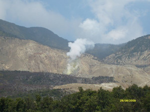
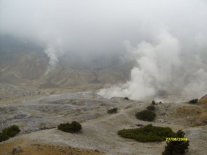
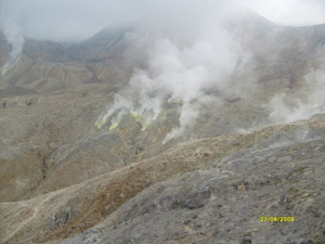
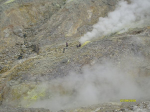
Mas Crater
For tourists both local and foreign tourists, researchers and the
climbers, Mas crater is a location that has always been the main goal of
all the way to the mountain. When compared with the locations of other
tourist objects surrounding mountains, craters Mas is a location that
was built in such a way and seems more advanced and developed. This is
because the crater Mas is the most important central location and
history of the series of eruptions Mount Papandayan. Here we can observe
the volcanic activity ongoing Papandayan appropriate time, in the crater
have 14 holes that emit smoke crack with a color different, some
sulfuric springs were also seen out from between the rock and of course
we can observe the activity Mas crater from close range.
Mas is a complex crater mountain berapai of the active area of 10 ha. In
this complex there is magma holes both large and small, these holes out
smoke and steam to create a variety of unique sounds.
In addition to the above the crater, several other craters such as Manuk
craters, craters and craters New Nangklak can also visit us to deepen
our observations of volcanic activity Papandayan.
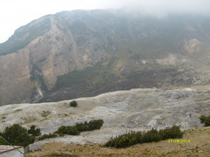
Tegal Alun-Alun
Tegal Square is the location of the oldest craters Mount Papandayan who has
long since dead and turned into an open field located nearly all the
plants covered by edelweis, so long as we are in this location we will
always smell a typical flower edelweiss. This location is like a valley
surrounded by mountains with complex peaks were towering. This location
also appears to spring next Ciparugpug River fumarola, solfatara and hot
springs that come out through cracks or crack rocks around it. For the
researchers, Tegal Alun-alun is always used as a place to observe wild
animals and plants endemic.
Besides the above, Tegal Square and several other locations such as wind
and cliffs Lawang Soni, is also a location that can be used as a place
to capture important moments such as pangambilan moment of sunrise
(Sunrise), which is amazing.
Death Valley (Valley Ruslan)
Death Valley (valley Ruslan) is one of the locations that are considered
dangerous for visitors on the mountain. This Dilembah found many
carcasses of dead animals trapped by poisonous gas. On December 18,
1924, reported an orderly named Ruslan fall into this valley and
unconscious, a few moments later paramedics confirmed dead Ruslan
because inhaling the gas CL2. After the events of the death of Ruslan
orderly, the valley was declared dangerous. And therefore this valley
then known, and given the name with the title of Death Valley or the
Valley Ruslan.
Cliffs Soni - Bandung, 28 August to 4 September 2009.
(This paper is dedicated to the Friends of the guide as friends
Papandayan Mount Gones, Kang Ilet, and input Kusnadiawan articles for
tourism services company Indotraveler Nusantara)
Related Topic :
Bandung White Water Rafting..
Garut White Water
Rafting..
Bandung Car Rent..
Bandung Outbound & Gathering Tour Package..
|
